
What Distinguishes Professional Luxury Real Estate Photography Services from Standard?
April 17, 2025
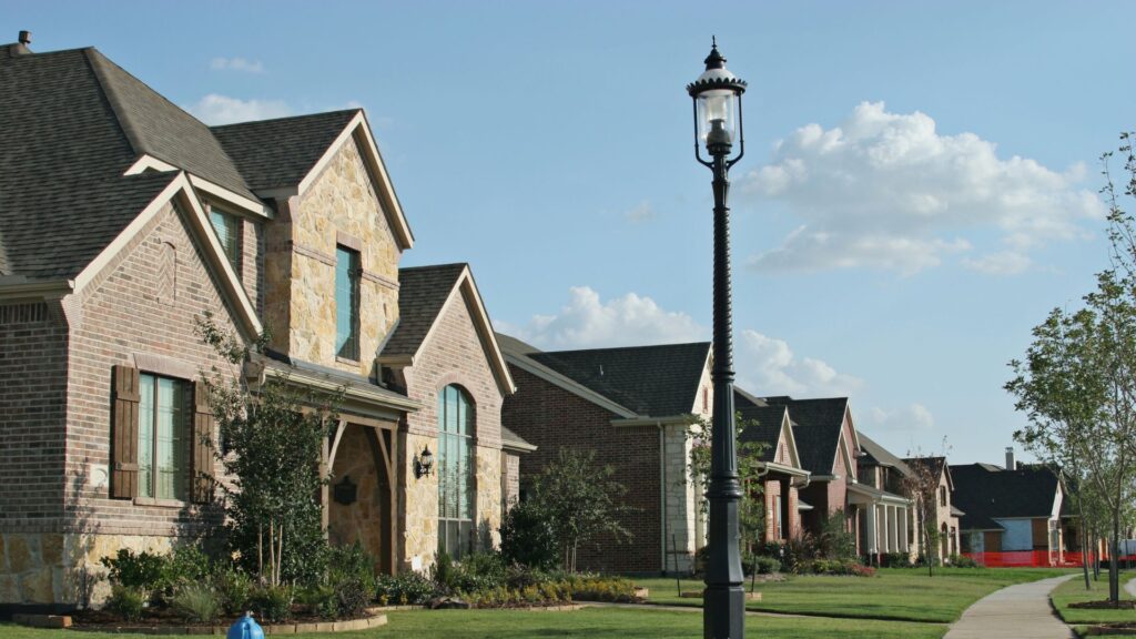
How Does Real Estate Photography Services Showcase a Property’s Unique Architectural Details?
April 21, 2025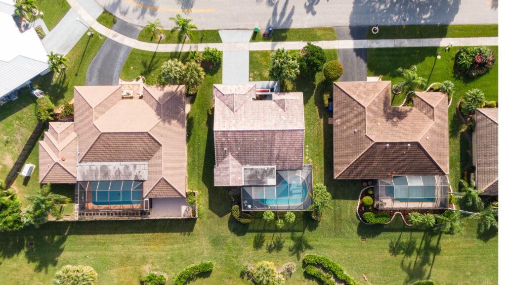
Selling properties can be tough without appealing visuals. Drone, aerial real estate photography now offers stunning perspectives that capture every detail of a property and its surroundings. This blog will explore the latest tools and techniques shaking up aerial real estate photography.
Keep reading to see how these trends could transform your listings!
Key Takeaways
- Drones like DJI Inspire 2 revolutionize real estate photography. They provide aerial shots that increase property views by 73%. The market for real estate drone photos is worth $398.9 million.
- AI editing tools improve lighting, color balance, and sharpness. Features like image recognition tag pools or windows for virtual tours, saving time and boosting engagement.
- Twilight aerial photography highlights properties during golden hour for emotional appeal. Virtual dusk editing mimics these effects digitally at lower costs while maintaining quality visuals.
- Advanced AR helps buyers visualize rooms with different furniture layouts or renovations using devices, bridging imagination with reality during a home evaluation process.
Increased Use of Drones for Aerial Shots
Drones revolutionize real estate photography by offering stunning aerial views. Models like the DJI Inspire 2 and Matrice 600 Pro capture high-quality images of properties. These devices save time by safely photographing entire estates from multiple angles in one session.
The drone photography for the real estate market is worth $398.9 million, taking up 5% of the total drone market. Listings with aerial photos receive 73% more views and inquiries. “Aerial shots highlight layouts, architectural details, and surrounding areas,” making them essential for competitive property listings.
Integration of Artificial Intelligence in Photo Editing
Artificial intelligence speeds up photo editing by automating tasks like improving lighting, color balance, and sharpness of drone real estate photography near me
. Algorithms analyze images and make enhancements to ensure professional results.
Using machine learning, AI recognizes patterns in digital photography for quick adjustments without manual effort.
AI tools can identify property features such as pools or windows through image recognition. This simplifies tagging for virtual tours and boosts user engagement. Computer vision also assists in refining photos, creating visually appealing content that attracts buyers.
These tools save time while increasing efficiency in real estate marketing strategies.
360-Degree Virtual Tours and Interactive Floor Plans
360-Degree Virtual Tours and Interactive Floor Plans provide immersive real estate experiences. These tools allow potential buyers to explore properties remotely, reducing the need for physical visits.
Virtual home tours offer a detailed property view, ensuring out-of-town or international buyers can make informed decisions. In 2020, Ruby Home Luxury Real Estate reported that 63% of new homeowners made offers after virtual property walkthroughs.
Interactive floor plans enhance remote property exploration by offering clear layouts tied to real-time views of each space. Features such as virtual staging give added value by showcasing furnished designs within the home digitally.
Future advancements may include augmented reality overlays for even more engaging virtual viewing experiences for real estate photography.
Advanced Augmented Reality for Enhanced Property Visualization
Advanced Augmented Reality (AR) allows potential buyers to visualize properties with immersive experiences. This technology superimposes virtual objects onto real environments, enabling interactive virtual tours where users can open doors or imagine renovations.
For instance, AR helps showcase how a room might look with different furniture styles or layouts, enhancing decision-making support during the property evaluation process.
This tool also provides detailed property information at a glance, with photography for real estate. Buyers can view key metrics like dimensions, material types, and renovation possibilities directly through their device screens.
“AR bridges the gap between imagination and reality by helping clients picture themselves in a space,” says industry experts. The added engagement benefits make it easier for buyers to connect emotionally with homes before stepping inside them.
High-Resolution and Next-Generation Photography Techniques
High-Resolution and next-generation real estate photography and videography techniques capture unparalleled detail. These methods ensure enhanced image quality with fine details visible in every shot. Ultrahigh resolution photography allows potential buyers to zoom in on textures and architectural features, providing a closer look at surfaces like brickwork or wood finishes.
This technology highlights even the smallest elements that make properties unique.
Innovative photo technology employs advanced imaging techniques to produce dynamic range and sharp clarity. Cutting-edge equipment enables photographers to achieve unmatched visual precision suitable for high-definition displays.
Real estate professionals benefit from this detail-oriented photography by showcasing properties more effectively, making listings stand out against competitors in the market.
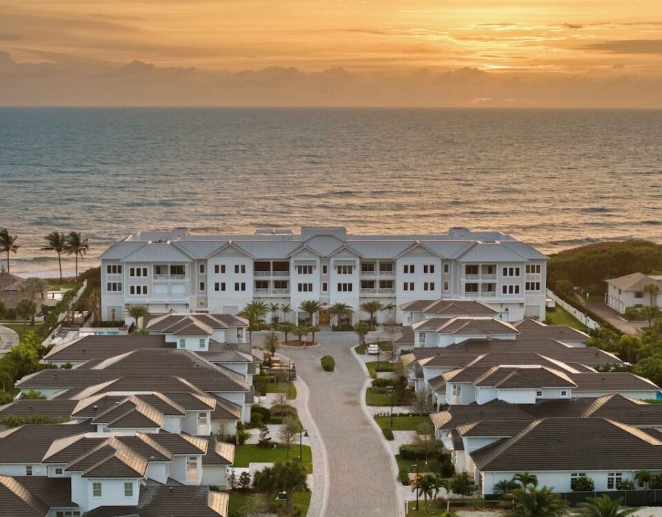
Twilight and Virtual Dusk Aerial Photography
Twilight real estate photography services capture properties during the golden hour, showcasing warm lighting and detailed landscaping. These shots create a welcoming atmosphere, enhancing exterior lighting and unique architectural features.
This method highlights curb appeal, drawing potential buyers by evoking emotions tied to comfort and elegance.
Virtual dusk editing replicates these effects digitally at a lower cost. Digital tools enhance images with soft glows, shadow adjustments, and vibrant skies without requiring sunset shoots.
This approach saves time while maintaining high-quality visuals for aerial photography in real estate marketing campaigns.
Mobile-Optimized and Vertical Images for Social Media
Real estate photography service now focuses on mobile-optimized and vertical formats for platforms like Instagram and TikTok. Buyers prefer visuals that fit smartphones. Vertical videos boost social media engagement, especially with short-form content marketing.
Creating these visuals enhances digital advertising strategies.
Vertical images improve visual storytelling for properties. They ensure better compatibility with mobile-friendly platforms, meeting a growing demand for quick, scannable content. This approach supports a mobile-first strategy while increasing visibility through social media marketing.
HDR and Color-Grading Techniques for Aerial Photos
HDR techniques balance lighting in aerial photography by combining multiple exposures. This process highlights details in shadows and prevents overexposure in bright areas. High dynamic range ensures polished images with vibrant colors, essential for real estate visuals.
Color grading enhances the aesthetic appeal of photos through saturation adjustment and color correction. Fine-tuning hues creates an atmospheric perspective, making properties stand out.
Professionals use post-processing software to achieve consistent and professional results, supporting visual storytelling in marketing materials.
Showcasing Surrounding Areas and Neighborhoods with Drones
Drones capture stunning aerial views of neighborhoods, parks, and water bodies. Residential real estate benefits from this by showcasing landscaping, outdoor amenities, and proximity to natural features.
Highlighting these elements helps potential buyers visualize the property’s location and its appeal.
For commercial properties, drones provide a clear view of building accessibility and nearby services. They also highlight layouts or available parking spaces. In land development projects, drone footage maps terrain and tracks construction milestones effectively.
Editing and Enhancing Aerial Footage
Professionals rely on advanced software to refine aerial images and videos for maximum impact. High-quality editing ensures visuals appear consistent, vibrant, and professional.
Selecting the Right Editing Software
Choosing the right editing software and a luxury real estate photographer is crucial for producing high-quality aerial real estate photos. Proper tools ensure efficiency and enhance the visual appeal of your images.
- Use Adobe Photoshop to retouch and refine images for a polished finish. It allows precise adjustments to lighting, colors, and textures.
- Apply Lightroom to manage and edit large photo collections. Batch processing speeds up workflows for multiple properties.
- Use AI-powered tools like Luminar Neo for automated enhancements. These tools improve image quality with minimal effort required.
- Opt for virtual staging software such as BoxBrownie.com to add furniture and decor digitally to empty spaces in property photos.
- Choose mobile-friendly editing apps like Snapseed for creating vertical content optimized for social media platforms such as Instagram or Facebook.
- Invest in AR technology software like Matterport for seamless virtual tour creation of properties using aerial photography.
- Select advanced HDR-compatible software like Photomatix Pro that handles dynamic range blending to highlight details without losing realism.
- Ensure your selected tool supports high-resolution outputs suitable for brochures, virtual tours, or mobile listings online.
Retouching for Natural-Looking Results
Retouching aerial photographs is vital for creating authentic real estate visuals. Advanced editing techniques help enhance details while maintaining natural-looking results. AI integration simplifies this process by adjusting colors, enhancing lighting, and removing distractions quickly and accurately.
These steps ensure that key property features stand out without looking exaggerated or artificial.
High-quality retouching increases a listing’s marketing appeal and attracts potential buyers. Well-edited aerial images showcase properties from unique angles, offering a clear view of the space and surrounding areas.
Listings with professional edits often receive more views and inquiries, highlighting the importance of careful photo enhancement in real estate photography services.
Challenges in Aerial Photography
Weather conditions often disrupt scheduled aerial shoots, making timing critical. Equipment malfunctions or technical issues can also impact the quality of captured images from a luxury real estate photographer near me.
Weather and Wind Conditions
Weather and wind conditions play a crucial role in aerial real estate photography. Poor atmospheric conditions can disrupt shoots and result in unusable images.
- Strong wind speed affects drone stability, causing shaky footage or blurred images. Drones with higher wind resistance are recommended for windy days.
- Rainfall damages drone equipment and camera lenses, making it unsafe to operate during wet conditions. Plan shoots on clear days to avoid risks.
- Sudden weather patterns like thunderstorms can interrupt flights, wasting time and resources. Check weather forecasts before scheduling any project.
- High humidity impacts image quality by fogging or clouding camera lenses. Use lens wipes or anti-fog coatings to ensure clarity.
- Low-light conditions from overcast skies reduce visibility and photo brightness. Use drones with high-resolution cameras to capture better details.
- Cold temperatures drain drone batteries faster, shortening flight times during winter months. Carry spare batteries to prevent delays mid-shoot.
- Changes in meteorological conditions, like unexpected gusts of wind, create safety risks for operators and drones alike. Ensure proper precautions when flying in unstable climates.
- Environmental factors such as dust or pollen in the air can affect photos by creating haze or specks on the lens surface. Clean the lens frequently while shooting outdoors.
- Wind direction influences flight paths and poses challenges for capturing smooth shots of properties facing strong winds.
- Aerial videography often depends on calm atmospheric conditions for smooth pans and steady visuals, requiring careful timing for optimal results.
Technical Glitches and Malfunctions
Technical glitches can disrupt aerial real estate photography. These issues often cause delays and reduce the quality of work.
- Equipment malfunctions may lead to unexpected camera failures during shoots, impacting image quality.
- Drone malfunctions, such as loss of control or flight system errors, may interrupt operations mid-air.
- Weather conditions like strong winds often amplify imaging complications and drone stability issues.
- Technical issues with control systems might result in limited navigation capabilities or signal loss.
- Aerial imaging problems often arise from software bugs that prevent proper operation during recording sessions.
- Photography disruptions happen when battery failures occur mid-flight, cutting sessions short unexpectedly.
- Imagine complications emerge if drones experience GPS malfunctions that hinder tracking accuracy for detailed shots.
Mitigating these problems begins by enhancing editing and aerial footage techniques effectively!
Conclusion
Aerial real estate photography continues to transform property marketing. Drones, AI tools, and advanced technology now create stunning visuals and immersive experiences. These innovations help buyers explore properties with clarity and ease.
As trends evolve, photographers must adapt to meet growing demands for high-quality images and virtual tours. The future of real estate photography looks bright with these cutting-edge tools shaping the industry with Seaside Imagery.
